‘Greater Nepal’ map in Mayor Shah’s office stirs debate
Law experts term the decision ‘childish’ and against the country’s constitution and national interest.

Anil Giri : Balendra Shah, the mayor of Kathmandu Metropolitan City, has placed a map of ‘Greater Nepal’ in his chamber as a symbolic counter to India’s placing of the ‘Akhand Bharat’ mural in its new parliamentary building in New Delhi.
Mayor Shah, who has been elected by Kathmandu’s voters and who had taken the oath of office and secrecy as per the constitution of Nepal, is accountable to the same constitution. But his latest decision has raised constitutional and legal questions. Can an elected people’s representative go against the letter and spirit of the constitution?
Some constitutional experts think his decision is unconstitutional.
Shah, who is currently in the Indian city of Bangalore, called his aides on Thursday and asked them to place the map of ‘Greater Nepal’ in his chamber in response to a mural painted on the wall of India’s new parliament building. “We have to remember the proud history of Nepal,” an aide of Shah told the Post, when asked why Shah had kept the unofficial map in his office. “Mayor Shah thinks that it gives a positive vibe of nationalism.”
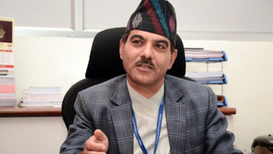
Bipin Adhikari, an expert on constitutional affairs, told the Post that only the constitution of Nepal-approved map should be used by elected representatives.
During a press conference in New Delhi, External Affairs Minister of India S Jaishankar remarked on the issue of ongoing ‘Akhand Bharat’ controversy: “It depicts the extent of the Ashokan Empire. Friendly countries will understand. You can forget about Pakistan, they don’t have the capacity to understand.”
“It is not a political issue,” said Jaishankar, adding “friendly nations like Nepal have understood India’s explanation, however, a nation like Pakistan does not have capability to understand it”. “This is a cultural map, not a political one. I hope our friendly neighbours understand it.”
In the old days, the Nepali territory was spread from Teesta in the east to Sutlej in the west; these areas now fall inside Indian territory. Those who are campaigning for Greater Nepal are asking for return of the land that Nepal controlled before the Treaty of Sugauli signed in 1816 following the Anglo-Nepalese war between the Nepali state and British-India.

https://kathmandupost.com/national/2023/06/09/greater-nepal-map-in-mayor-shah-s-office-stirs-debate
After the Sugauli Treaty, Nepal ceded the land from the Mechi River to Sikkim-Jalpaiguri-Teesta in the east and from Mahakali River up to the Sutlej in the west. On March 4, 1816, the Sugauli Treaty was signed between Nepal and the East India Company, which confined the territory of Nepal to Mechi-Mahakali. The total land mass that Nepal ceded during the Treaty of Sugauli was more than 60 percent of today’s Nepal.
“Land alone does not constitute a country, population is as important. When a responsible elected representative takes such a decision, this is something that needs to be looked at very carefully,” said another constitutional expert.
Noted cartographer Buddhi Narayan Shrestha also decried Shah’s decision.
“Shah is an elected mayor of Nepal’s capital. His position in the protocol is equal to that of a state minister. He should be mindful of this,” Shrestha said. “He should not do anything that may result in tensions between the two countries. Shah should follow the constitution.”
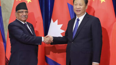
During the official visit of Prime Minister Pushpa Kamal Dahal to India, the border dispute with India figured in the bilateral meeting.
Speaking at a meeting of the National Assembly on Wednesday, the prime minister said: “We raised the issue of a new Indian map which is placed in the Indian parliament. We raised this issue on a serious note. But the Indian side responded that it was a cultural and historical map and not a political map.”
The new Indian mural includes territories like Lumbini and Kapilvastu, the birthplace of the Buddha.
Nepal and India are already in a boundary row over Kalapani, Lipulekh and Limpiyadhura—the Nepali side has, for long, been claiming the territories as its own.
After India in November 2019 unilaterally issued a new map by including the three areas within India and refused to entertain Nepali concerns, Nepal too, six months later in May 2020, issued its own map by including the three areas within its borders.
This dispute took the bilateral ties to a new low.
Mayor Shah is currently in India for his wife’s treatment.
The new Indian parliament was inaugurated by Indian Prime Minister Narendra Modi on May 28. The creation of the ‘Akhand Bharat’ mural in the parliament building has invited strong protests from Nepal, Bangladesh and Pakistan, as per some Indian media reports.
“The mayor of Kathmandu should follow the rule of law and he does not have the freedom to endorse the controversial concept of ‘Greater Nepal’,” said Adhikari. “Yes, it is just a concept like ‘Akhand Bharat’.